Researching for this article, I encountered an image from my personal nearby neighborhood in New York taken in 1917 showing the construction of the Flushing Subway Line in Queens; the area was rural and essentially farmland at the time; presently it is a vibrant residential, commercial, industrial and recreational neighborhood; see Figure 1. Although this line was not underground, the expansion of the New York subway around the turn of the 20th century was instrumental in the urban development of New York City as we know it today. Based on an article by Thomas Jablonski in 2006 entitled “New York City’s Subway Century – Rail Transit’s Role in Growth and Development”, at the end of the 19th century and early 20th century, New York City’s population was mostly in lower Manhattan within walking distance to the light industry located in the area; at the time, the city was amongst the highest density cities in the world because of the confinement of its residents to a small area in Manhattan.
Fig. 1 – The extension of the Flushing Line along Queens Boulevard, in 1917, completely changed the rural landscape of Queens
The massive construction of New York City subway lines between 1913 and 1940, during which 180 route miles including 12 bridge and subaqueous tunnel crossings overcoming the river barriers, integrated Queens, Brooklyn and the Bronx with Manhattan. This opened new lands for the development of affordable, low-density housing for middle-class and working-class families while allowing them to fast and convenient access to their workplaces. Soon the rural areas in the outer boroughs was replaced by long boulevards and tree lined streets with single or two-family homes and apartment houses. Open parks, institutional facilities, and recreational areas were soon to follow. These transformations also brought to the new neighborhoods local commercial and light industries forming mini-societal areas within the larger metropolitan.
By 1940, when the initial NYC subway system was mostly completed, the population of the city was about 7.5 million, similar to the population now of 8.3 million residents providing connectivity to the metropolitan and prosperity to the City with over 5.5 million riders per day in 2019. Although during the present COVID-19 pandemic, the subway ridership dropped to as low as 10% of its former daily passenger use, the system continued to provide lifeline for essential workers who shouldered the safety and wellbeing of New Yorkers during this period. It is anticipated that NYC subway ridership will return to its pre-pandemic level within one or two years. The subway will continue to be New York’s lifeline, sustaining its economic and physical vitality; no one can imagine New York City without its subway system.
We see similar examples throughout the world of the role of the subway systems in urban development and connectivity of neighborhoods and localities. Examples include Washington Metro, Toronto subway system, London underground, Seoul Metro, Hong Kong Subway, Beijing Metro and recently the Paris Metro expansion, all resulted in successful urban development and economic growth.
However, not all stories are success stories; for example, in an article written by Professors John Landis and Robert Cervero in 1999 entitled “BART and Urban Development”, The Bay Area Rapid Transit (BART) did not spur the intended developments. They conclude that BART achieved one major success and many missed opportunities. BART was instrumental in the development of the commercial hub of San Francisco maintaining its preeminence as the business and financial center, but it failed to trigger similar achievements in the East Bay and reinvestment in developments in downtown Oakland, Berkley or Richmond. They concluded that the benefit of rail transit in urban development is not automatic, but it can be a catalyst for urban development through the collaboration of transit agencies, local governments, and private developers to overcome obstacles of policies, design, and financing.
This article will examine the benefits of the use of the underground space and its potentials in urban planning.
The Needs of Underground Space
In the last few decades, underground space became increasingly important for the development of societies. Population growth, growth of metropolises, migration to cities, environmental awareness, and increased needs for transportation, water, utilities, storage, security, and sheltering encouraged the use and the development of underground space.
In 2018 thirty-three megacities, each with a population of over 10 million people, and collectively housing more than 500 million people existed in the world; it is estimated that by 2030, 60% of the world population will be residing in urban areas and the number of cities with population over 5 million inhabitants will be over 100; this trend of urban growth is expected to continue throughout the 21 century.
The large megacities will grow even larger and the number of megacities will increase creating more megacities and super megacities. Figure 2 shows mega cities in 2015 and their expected growth by 2025. This shift in population centers necessitates the development of infrastructure in cities to support the population surge including provisions of efficient transportation systems; reliable utilities such as power, water, sewer, and communication systems; and supporting infrastructures. Unfortunately, population growth is outpacing the development of infrastructures to support such growth and the limited available surface spaces suggest that the logical location of these systems is underground; yet most cities lack general policies about the utilization of the underground space as part of its urban planning.
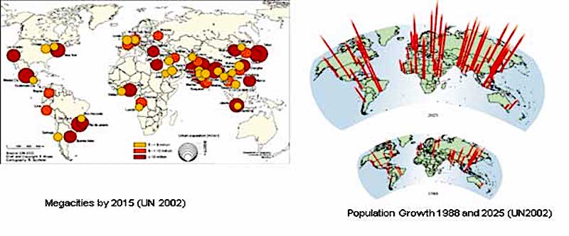
Megacities – Source – “Megacities and our Global Urban Future” 2005 – Earth Sciences for Society Foundation, The Netherland
Sustainability and Resiliency of Underground Space
Environmental decline, climate change and the increased awareness of the need of sustainable development invite the use of underground space. Increasing the demand for better living conditions in urban areas can be achieved by placing infrastructure facilities, utility distribution, transportation systems, and other supporting structures underground. The use of the underground space provides significant direct and indirect benefits. In general, the underground placement of the lesser facilities such as parking, transportation, utilities, storage, etc. provides the opportunity to develop the land for better and nobler purposes such as residential, commercial, institutional, and recreational facilities including parks and green spaces. The multiuse of the land enhances the quality of life and provides environmental and economic benefits to the users and to the society at large.
The use of the underground space is sustainable. It provides isolation from the elements reducing power consumption and carbon footprint. Thermal isolation is naturally provided by the ground with a uniform and moderate temperature level throughout the year; it reduces the needs for climate control and its associated costs and environmental impacts. The use of underground space provides additional environmental benefits in term of visual effects, air quality by removing vehicles from streets, less congestion, and a reduction of noise and vibration resulting in a better quality of life at the surface. The use of the underground facilities improves the local and global ecological cycle.
The use of underground space provides resilient facilities. Natural disasters such as earthquakes, hurricanes, tornadoes, thunderstorms and flood have lesser impact on underground facilities because they are protected from the elements. The impacts of seismic event are far less on underground structures than above ground structures; structural oscillation and amplification effects for underground structures are far less than surface (or above surface) structures. Underground facilities are more cost effective considering life-cycle cost and triple bottom line since design life of all underground facilities exceed 100 years; many existing operating tunnels are much older such as the Thames Tunnel in London constructed in 1843 and the London Underground which was first opened in 1863.
RELATED: Why Tunnels in The US Cost Much More Than Anywhere Else in The World
Underground Space as the Third Dimension in Urban Planning
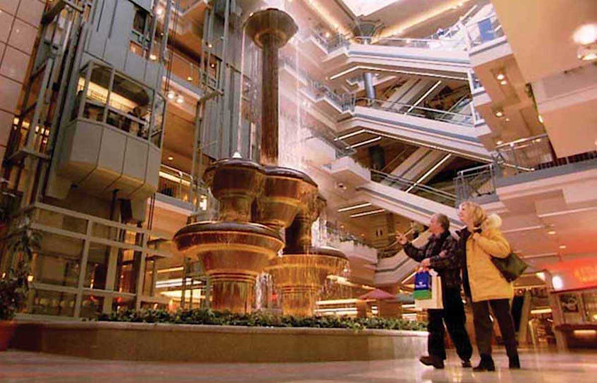
Underground space provides opportunities for better urban development. The use of subsurface space allows for a holistic urban planning benefiting from the three-dimensional space with suitable integration of the spaces above and below the surface creating opportunities for more efficient use of the urban land. It also provides the opportunity of creating a more desirable, less dense surface environment by creating more open spaces and outdoor recreational facilities and parks. For example, building an underground sport arena or a shopping center while developing the area above it for outdoor recreational facilities or providing green spaces allow multiple uses of the land. Often these developments are extended several levels below the surface with various functions at various levels connecting to transit system, underground parking, commercial levels, services, and connections to office buildings, with other adjoining developments. For example, Montreal’s Underground City (La Ville Souterraine) consisting of a network of 29 km (18 miles) of tunnels and underground space spread over an area of 12 square kilometres (3,000 acres) provides efficient use of the underground space. See Figure 3. Another example of efficient use of the underground space is the implementation of utility corridors, also known as utilidors in which various utility services are organized in a planned underground space rather than placed arbitrarily as various utility owners see fit often impacting other utilities and impacting surface traffic, businesses and the public when repairs or replacement are needed. Figure 4 shows an example of utilidor from Amsterdam.
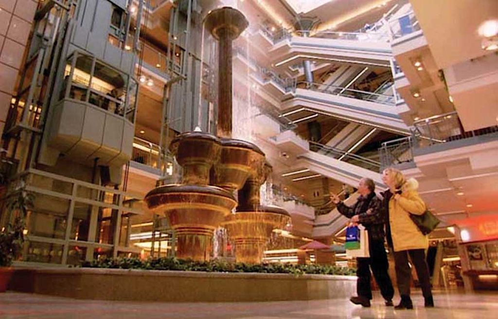
Montreal Underground City
In the last few decades, many major cities in the world started placing many of its facilities and urban services underground and developing real underground cities – but often not within an overall urban planning strategy. A report prepared by ITA/ITACUS/ISOCARP entitled “Think Deep: Planning, development and use of underground space in cities” addressed the needs and the challenges of integrating underground space planning with urban planning dealing with the third dimension of space planning.
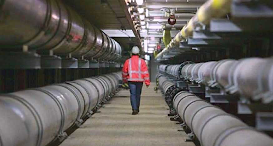
Utilidor in Amsterdam carries multiple utility lines SOURCE: Courtesy H. Admiraal.
For example, to meet the growth of population in London, several underground infrastructure projects were planned and are under construction including Crossrail, Thames Tideway Tunnel, Northern Line Extension, and London Power Tunnels; yet there is no holistic planning for the underground space. While only six of the 32 London boroughs consider underground structures in their plans, all are related to residential basement design standards and none deal with the overall planning of underground space in a holistic manner.
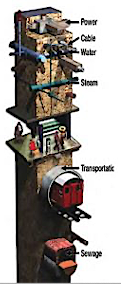
New York underground systems developed at multiple levels without controlled underground space planning – Courtesy of Elizabeth Reynolds and Paul Reynolds
The urban planning system in New York City has evolved since 1811 with the establishment of the grid pattern of a 7-mile stretch of Manhattan consisting of 11 major avenues and 155 cross streets creating blocks of approximately 250 ft by 900 ft. In 1916, New York implemented the first zoning resolution and by 1936 it established the City Planning Commission. Although city planning agencies in both London and New York share similar objectives for improving the quality of their urban environments addressing issues such as housing, neighborhoods, parks and public spaces, transportation, energy, water supply, waste management, air quality, climate change, resiliency, etc., neither have any underground spatial planning or design strategies. They are not alone in this regard, very few cities throughout the world have such underground spatial use policies or standards.
By contrast, in Tianjin, China, for example (as well as other Chinese cities), in which the urban development is accelerating rapidly, and utilization of urban underground space entered a rapid development stage, the city planning in 2004 carried out an extensive research on the development and utilization of underground space. This was documented in a plan entitled “Comprehensive Utilization of Underground Space Planning in Tianjin Central City (2006-2020)”, which is aligned to the City Urban Master Plan. There, underground space planning was prepared at the macro, meso and micro level corresponding to the underground space use. The master plan is based on distribution of the underground space in multiple layers, namely shallow (10m), middle (20m) and deep (30m). Space allocations of the various layers are based on their utilization for parking, services and utilities, commercial, transportation, etc. See Figure 6. Underground space planning guidelines are used to incorporate underground space into the urban regulatory planning system, and to guide the urban construction as a basis for urban management. Currently, the total construction area of underground space in Tianjin central city has exceeded 15 million square meters (160 million square feet), but it is still focusing on the basic level of the shallow and middle layers. With the recent completion of 9 subway lines totaling 470 km (294 miles), the city focused on the development of transportation urban hubs and urban public centers integrating the surface planning with the underground space utilization; yet the construction of underground rail transit cannot keep pace with its urban development. This approach is also adopted by other cities in China including Beijing and Shanghai.
Fig. 6 – Tianjin underground surface planning allocate different levels for different facility types
The strong policies and the strong administrative controls for implementation in China would not necessarily be possible in the United States. However, policies that facilitate effective long-range planning of underground space use, as are found in locations such as Singapore or Helsinki, helped those locations move closer to sustainability goals and integrating underground space with urban planning, can be applicable to many cities in the United States. For example, policies that enforce preservation of the surface environment while permitting facility expansion underground would provide a reason for moving more infrastructure underground in a deliberate planned approach. Another example is the policies adopted in Japan allowing public agencies the rights to develop deep underground space under private properties avoiding lengthy legal barriers and allowing more versatile and rapid development of underground projects.
Equity in Underground Space Planning
The decision to place transit systems underground often faces many challenges among various competing interests. Political views, community interest and lifestyle, commercial benefits, and tax incentives often affect the route, alignment, configuration, station locations and surface connections with potential future developments. Impact of construction on traffic, businesses and the daily lives of communities could also deter public acceptance of an underground transit system. The public in affluent areas may also be concerned about security and integration fearing that mass transit system will bring a large number of unknow and undesirable people to their neighborhood; a case in point is the lack of a subway line to Georgetown in Washington, D.C., despite the fact that a subway line was planned since mid 1970s. On the other hand, when a development is successful around station locations, real estate prices rise, displacing lower income residents and gentrifying the neighborhood. This has been seen in many large cities with underground transit system such as New Yok, Washington, and Los Angeles. In spite of the wide spread of New York City subway system, the 4th Regional Plan issued in 2017 identified that more than one third of all New Yorkers don’t live within walking distance of a subway station. Most are low-income neighborhoods and communities of color for whom transit access is disproportionately important and who have no other means of transportation to their workplaces. Similarly SPUR in the Bay Area in California in its report “The Future of Transportation” issued August 2020 identified equity as an essential strategy of a successful transportation planning and made recommendations to “Set prices to promote efficiency and equity”.
It is of critical importance that new or extended underground transit lines or new systems address these disparities by establishing policies regarding land use around stations to minimize displacement of the residents such as the implementation of mixed-use development and affordable housing with public amenities meeting environmental and sustainability goals; thus creating vibrant public places fostering a strong economy benefiting everyone including the local communities.
Final Notes
Generally, all over the world, urban planners tend to overlook the invaluable assets of the underground space, “the final frontier”. Most urban planers and policy makers are unaware of the benefits and the opportunities the underground space has to offer. Population growth, migration to metropolises, and the growth of large cities in size and number, outpace the development of supporting infrastructures. The availability of space at the surface is diminishing and quality of life and the livability of cities are threatened. Urban underground space forms a societal asset, often unappreciated by policy-makers and urban planners.
Understanding the potentials of underground space is not enough, realizing its actual potential and facilitating its development will require an awareness program and a continual dialogue among many stakeholders, including policy-makers, city planners, engineers, developers, and the public.
Underground space development should be part of city planning following the context of an existing urban plan. With the predicted population growth and the growth of megacities, efficient use of underground space promotes sustainable development, improves the urban environment, preserves natural resources, and accomplishes long-term, triple-bottom-line economic benefits.
Nasri Munfah is a Senior Vice President and Director of Tunneling and Underground Engineering Center of Excellence for AECOM. He is responsible for developing and implementing the firm’s long term strategic tunneling growth plan; he oversees the firm’s tunneling and underground projects and provides leadership in project pursuit and delivery, the development of innovative solutions, recruitment and the professional development of staff. With over 40 years of experience in tunneling and underground engineering, he was responsible for the successful delivery of multi-billion-dollar projects in DBB and Alternative Delivery Methods.

